Column
The Amazing Things That Are Possible With Just a Clock
Experiencing Time Zone Changes Firsthand While Traveling Toward America's West Coast
Back in the years when all road maps were printed paper, I rented a car in New York in the middle of winter and set off on a journey to Los Angeles on America's West Coast. Based on memory, I proted my journey on Google Maps, It was a distance of 2,966 miles (4,773 kilometers) . It takes 44 hours with no stopovers or breaks. In actuality, it took me six days to cover that distance, and the wide-open vistas and dry smells which accompanied my journey remain in my memory. This journey was a unique one in which I experienced the transitions between time zones gradually, a bit at a time. Allow me to provide some background.
The continental United States is divided into four time zones. When traveling westward, you receive an extra hour to enjoy restaurants and shops before they close whenever you cross the divide into a new time zone. Although this transition can be experienced when traveling by airplane, the relatively slow travel speed of a car enables you to take it in little by little rather than all at once, which makes for a uniquely fascinating experience.
One of the most interesting facets of the experience was tracking time at which the sun set every day. The clock on the dashboard of my rental car was set at New York time (Eastern Time) throughout the journey, and the further west I traveled, the later the sunset time became, with the disparity increasing day by day. In addition, because I was traveling southward as well, the temperature rose slowly, as if the seasons were passing by on fast-forward as I drew nearer to summer.
Tracking Sunrise and Sunset Times from the Perspective of a Migratory Bird
Let's change our perspective a little. Migratory birds often embark on journeys spanning several thousand kilometers. As humans, though, there's no way of knowing whether they pay any heed to the length of the day. However, if we were to record the sunrise and sunset times seen by such a bird, we would find ourselves.
able to track—only roughly, of course—the route taken by that bird as it travels. The time which falls exactly between the sunrise and sunset time in a day is known as the "meridian transit time," and the time difference between "noon" in this sense on a clock at the point of origin and the current location's noon can teach us the difference in longitude between the two points.
This exact same principle was utilized during the Age of Discovery by seafarers to determine the position of their ship: they referred to a chronometer (a type of clock) synchronized with Greenwich Mean Time, and compared this with measurements of the sun's meridian transit time, in order to calculate longitude.
But what about latitude? A ship in the Northern Hemisphere can determine latitude based on the height of Polaris above the horizon, but a migratory bird is unlikely to utilize such celestial observation (or perhaps it does...?). However, the changing length of the daylight hours, as measured from sunrise to sunset, can provide a rough estimate of one's latitude. In the Northern Hemisphere, the day becomes longer the farther north you travel in summer or south in winter. Near the vernal and autumnal equinoxes, though, the length of the day and night are almost exactly the same, which makes this method temporarily ineffective. However, despite this weakness, it enables a rather ingenious approach to tracking one's position on a global scale using just one simple device comprising a photodiode (light meter), quartz clock, data logger and battery.
Known as a geolocator, this compact device has proven useful in tracking the behaviors of endangered animals. Let's take a look at a specific example:
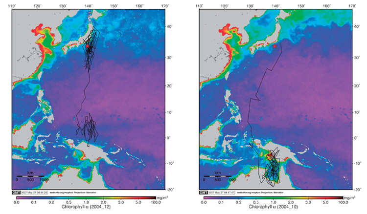
In the diagram below, you can see routes that were recorded for two streaked shearwaters, a type of endangered seabird, as they travel away from Mikurajima Island in Japan's Izu Islands (officially part of Mikurajima-mura Village, Tokyo) and then return several months later. During their breeding season, these birds traveled for more than 5,000 kilometers while having their journey logged, flying to northern New Guinea and northern Australia and then back again. Each bird was equipped with an anklet-type geolocator that had not only a light meter and similar equipment as mentioned above, but also a means of detecting electrical resistivity to determine whether or not the device was immersed in seawater. The results told researchers that the streaked shearwaters spent roughly 80 percent of their time floating on the sea's surface, providing valuable and previously unknowable information about the behaviors of these wild birds and other wild animals.
 Source: Akinori Takahashi et al. "Post-breeding movement and activities of two Streaked Shearwaters in the north-western Pacific." Ornithological Science 7, June 2008, The Ornithological Society of Japan.
Pioneering New Fields Using Technology That is Both Old and New
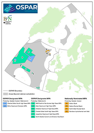
 The OSPAR Commission, whose members include 15 European countries as well as the EU, have established this marine protected area (MPA) in the North Atlantic Ocean.
Known as the Evlanov Sea Basin MPA (area 8 in the figure above), it occupies roughly the same area as that of France. It was established as the first-ever open seas MPA in October 2021 based on gathered tracking data from breeding grounds for seabirds and other marine life.
Source: OSPAR Commission website.
This method of using small devices to track wild animals and analyze movement data and behaviors is known as bio-logging, a Japanese-made term based on existing English words (from the loanwords baio rogingu) that went on to become a new English word of its own used throughout the world.
I first learned about bio-logging through the report of a penguin researcher. Such researchers use accelerometers similar to what we find inside pedometers to track penguins and compare ratios of food-gathering activities to rest periods. They are a triaxial type (that measures X, Y and Z axes) much like those found in smartphones which enables monitoring of when a penguin is standing, sleeping, sliding on its belly or waddling along. This device also measures penguin swimming speed. Furthermore, the addition of a pressure gauge enables measurement of diving depths, and the use of a thermometer at the base of the throat enables detection of regurgitation when feeding chicks. Because penguins are known for always returning to the same nesting site, researchers are able to recover such devices—although this is undoubtedly a challenge in its own right. Due to the success of the abovementioned project, the approach began to spread rapidly among biological researchers everywhere.
At a later date, I had the opportunity to interview a researcher who utilized ultra-compact GPS receivers to track streaked shearwaters. Just as with penguins, it was possible to wait near their nest in order to capture the streaked shearwaters and attach the devices, and then recover them later (again, this is probably quite a challenge to pull off in reality!). As it turns out, the researcher in question cited as a precedent in their report the aforementioned geolocator equipment.
When talking about the topic of global-scale measurements, the focus often shifts to GNSS. As equipment in this field evolves rapidly, becoming smaller and faster than ever before, we are seeing the emergence of trackers that weigh less than 10 grams and are capable of transmitting GPS-based positioning information over 5G networks. Regardless, the non-GPS geolocator, which relies upon changes in light levels, has always offered the advantages of ultra-small size and ultra-light weight. Some geolocators weigh less than 1 gram and can be used for 1 to 3 years' time. They have even been used on insects, and their applications are expanding into areas such as food-chain tracking.
The concept of "clockwise," which reflects the direction in which an analog clock's hands rotate, has its origins in the direction that a sundial's shadow moves when viewed in the Northern Hemisphere. Later on in history, when humans developed clocks that operated without relying upon the sun's movements, we came up with a means of measuring position using both the sun and a clock in combination. The clock is a simple device which represents a major discovery in the history of human civilization, and it is now being used to make further discoveries and better understand ecological systems. The researchers who pursue such efforts are, without a doubt, the successors to said progress by human civilization, and they deserve our utmost respect.
Writer introduction

Mr. Mitsunari Kita Science and technology writer
Born in Ishikawa Prefecture in 1964. Based on his experience in covering industrial technology, cutting-edge technology, and space development, he is passionate about unraveling and conveying difficult topics in an interesting way to people of all ages, from children to senior citizens. From 2009 to 2014, he was a member of the editorial board of "JAXA's," the official magazine of the Japan Aerospace Exploration Agency. Author and co-author of the following books: 『あなたにもミエル化? ~世間のなりたちを工学の視点から~』(幻冬舎mc)、『私たちの「はやぶさ」その時管制室で、彼らは何を思い、どう動いたか』(毎日新聞社)、『東京大学第二工学部70周年記念誌 工学の曙を支えた技術者達』(東京大学生産技術研究所) etc.,
* All registered trademarks used herein are the property of their respective owners.
Pick up
Column
FURUNO Column
-
Common Problems That Affect GPS/GNSS Time Synchronization

-
How to select GPS/GNSS antennas for time synchronization

Column by Mr. Mitsunari Kita (Science and technology writer)
-
The Observation Network Created by the Earthquake Proves Useful for Accurate Timekeeping (Part Two of Two) - A Solution to the "Mr. Higgins Problem" in Space -

-
The Observation Network Created by the Earthquake Proves Useful for Accurate Timekeeping (Part One of Two)

-
FURUNO ELECTRIC Joins Experts From Around the World on a Norwegian Island for Jammertest 2024

-
Unraveling the Mysteries of Venus Based on "Occultation"

-
Atoms as the Basis for Measuring Both Fleeting Moments and Near-Eternities

-
Time Progressing with a Speed Difference of Just 4.4647 Ten-Billionths!

-
Critters Who Revitalize Forests Through the Spreading of Food Caches

-
Small But Significant Variances in Gravity and Time (Part Two of Two)

-
Small But Significant Variances in Gravity and Time (Part One of Two)

-
Why the GT-100 Time-synchronization GNSS Receiver Module is Like Fragrant Soup Curry

-
What Rainbows Can Teach Us About Dual-Band GNSS

-
The Amazing Things That Are Possible With Just a Clock

-
When Subterranean Earth Meets Outer Space

-
Using the TB-1 and GT-100 at a "Multipath Dojo" in the Major Metropolis of Osaka

-
The Disaster-struck Field Time Sync Generator TB-1: True Performance Revealed Through a Lightning Strike

-
Knowing the "Now" of Our Earth Through GNSS

-
The Reason GPS Counts Time in 1.5-second Intervals

-
Similarities Between "On My Count!," the 117 Notification System, and GPS

-
Reliable Clocks Help Us Find a Silver of the Clouds

-
Why Time Synchronization is Vital for Criminal Investigations, Seismograph Measurements and Solar Wind Observation

-
What Was "Cesium" About Cesium Akina?

-
Updating Analog Broadcasting with GNSS Time Synchronization Technology

-
The Long History of One Second (Part II)

-
The Long History of One Second (Part I)

-
A Solo Journey - Three-liter Microsatellite Mission Support via GPS (GNSS) and Satellite Communication -

-
A Solo Journey - The GPS (GNSS) Tracking System That Helped Kenichi Horie Cross the Pacific -

-
The Day After a Superflare - Effects on power and wireless communication infrastructures -


