Column
Small But Significant Variances in Gravity and Time (Part One of Two)
Monitoring a Moon Landing
Even seemingly mundane numbers can bring feelings of amazement and wonder to those who know their true meaning.
At 12:20 a.m. (JST) on January 20, 2024, Japan's pinpoint moon lander "SLIM" entered its final descent phase, with people from all over watching via the Internet.
As its name implies, SLIM, or Smart Lander for Investigating Moon, is an exploration vehicle designed for high-precision Moon landings, which are very challenging to achieve. It weighs about 200 kilograms (440 pounds), making it significantly smaller and lighter than exploration vehicles employed by other leading nations in the field. When converted to numerical figures, SLIM's ability to land at the target site realizes high precision to within just 100 meters, which is far greater than the several-kilometer to several-dozen-kilometer distances seen with other nations' landers. It goes without saying, of course, that this represents a world first.
SLIM was developed by the Japan Aerospace Exploration Agency (JAXA), and during the landing, they transmitted telemetry data sent by SLIM in real time for those who wanted to watch this impressive event unfold. The planned and actual trajectories were displayed on a graph, and numerical data on lander attitude, engine operations, remaining fuel amount, altitude and so forth were shown in easy-to-read fashion in a single window. This live, raw data sent from near and on the Moon's surface was enjoyed by fans of space exploration everywhere.
During the final descent phase, SLIM fired its engines as it saw fit, based on its own determinations, in order to decelerate and maintain attitude, at which time the numbers and graphs began fluctuating wildly. Although coming across as something akin a video game at a glance, the information on-screen was, in fact, conveying real-time changes taking place near the Moon's surface. As SLIM descended to 50, 10, 8 kilometers in altitude, those numbers began to undergo increasingly rapid changes. As it got down to 500, 300, 100 meters, however, some of those figures come to a complete standstill.
If the vehicle had failed in its landing and crashed on the Moon's surface, its equipment would have sustained damage and the signal been lost, but the telemetry information screen remained connected and online, silently streaming data. Fans of space exploration would, at this point, have noticed one particular data value of interest on-screen.
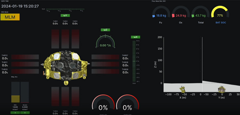 A screenshot of SLIM's telemetry information screen. Source: Institute of Space and Astronautical Science (ISAS) and JAXA SLIM project gallery webpage (https://www.isas.jaxa.jp/home/slim/SLIM/gallery/index.html).
Exciting Acceleration Rate Data!
That data value was the IMU, or inertial measurement unit, readout. It is known that Earth's gravity strength is approximately 9.8 m/s2, and that the Moon's is roughly one-sixth of that. The aforementioned telemetry screen displayed a value of—you guessed it—exactly 1.628 m/s2. This told onlookers that the sensor data was being correctly transmitted back to Earth, that the value in question was not at odds with the rules of physics, and that SLIM was functioning properly. In other words, SLIM had decelerated and arrived on the Moon's surface— the landing was a success!
I also watched the landing live, but even I hadn't expected people to get so worked up about an acceleration rate number.
Impressive Results from the SLIM Landing
After making its landing, SLIM remained stationary in an upright-standing position, which was confirmed via the photographs taken by the sub-unit; many of you have likely seen this impressive image somewhere on the news already. Moreover, it became clear that the lander had reached its target with an error far below the 100-meter mark, ending up just 55 meters from the intended landing site regardless of the breakdown experienced by one of the two craft's engines during the final descent phase. If both engines had remained functional and operating as planned, the lander may have achieved even more impressive accuracy, down to just 3 or 4 meters from the target.
In addition, SLIM managed to survive three solar nights on the Moon's surface, each of which brings ultra-low temperatures and lasts for two weeks. This extended length of service was not anticipated by original mission planners, and as a result, the lander was able to send large amounts of valuable scientific data during its sojourn. It would be an understatement to call this mission a great success, and as a competitor in the international race to explore the Moon's surface, it represented a major triumph for Japan.
A Rare Opportunity to Take Part in Precise Gravitational Measurements
Thinking back over my own personal experiences, I can recall a time when I was similarly impressed by numerical figures—figures related to gravitational acceleration. Those numbers were variances at a scale of one one-millionth relative to Earth's gravity.
In the summer of 2019, I attended an overnight educational program put on by the Geospatial Information Authority of Japan (GSI) known as "Geodesy Summer School." "Geodesy," also known as "geodetics," is a field involving the measurement of the Earth. GSI's summer camp was designed to bring together students pursuing future careers in geodesy and foster new bonds of friendship among them while training them as next-generation geodesists and field researchers. I tagged along closely for two days to observe and gather article information. Participants enjoyed a wide array of activities, but one that sticks out in my memory was the hands-on practice with actual vertical gravity gradient (VGG) calculations.
The phrasing used for these gravity variations in Japanese is juryoku enchoku kobai, which comes across to a layperson as something like "gravitational vertical inclines"—a phrase that did nothing but confuse me at first.
Luckily, the instructor provided an explanation which cleared up my confusion: The term kobai in this case doesn't mean "incline," but instead "gradient," a rate of gradual change or variation. Therefore, juryoku enchoku kobai means the rate of variance among (vertically acting) gravity. In other words, how much the gravity strength changes based on elevation. Geodesists understand this, as it is very basic terminology in their field of expertise. So the only one feeling confused at the time was this writer, sitting in the back of the room and scratching his head.
Reasons for Slight Gravitational Variations
But I've strayed off topic; let's return to the subject at hand. There are several reasons for gravitational variations in certain locations.
One reason is Earth's rotation. Gravity on Earth is a force that combines a pulling force toward the central core of the planet and a centrifugal force resulting from the spin of the planet. Centrifugal force changes in proportion to speed, so it is larger near the equator where the radius (distance) to Earth's axis of rotation is larger, and smaller the closer one travels to the poles. Furthermore, because centrifugal force acts in a way that decreases gravitational force, Earth's gravity is weaker near the equator.
The National Institute of Advanced Industrial Science and Technology (AIST) reports a gravitational strength of between 9.803 and 9.807 m/s2 in Hokkaido, which is Japan's northernmost prefecture, and a strength of between 9.789 and 9.792 m/s2 in Okinawa, Japan's southernmost prefecture. If an object were to be weighed using the same scale in both Hokkaido and Okinawa, the resulting weight figure would be roughly 1.8 percent smaller in Okinawa.
During commercial transactions that entail weighing, equipment adjustments must be made based on location. This is also the reason that scales used at home to check body weight ask one's location information during the initial product setup phase following purchase. In short, accurate weight measurement is only possible if gravitational value variances are taken into account.
Another factor causing slight gravitational variations on Earth is distance from the planet's center of gravity. Newton's law of universal gravitation states that all particles attract all other particles with a force that is proportional to the product of their masses and inversely proportional to the square of the distance between them. Therefore, when you lift something up to a higher elevation, you are taking that object farther from Earth's center of gravity, and thus ever-so-slightly reducing the gravitational pull acting on that object.
In addition, subsurface distribution of mass has an effect on gravitational pull. Metals and other substances with higher specific gravities will, if present in comparatively high quantities, create stronger gravitational pull, whereas fluids which have relatively low specific gravities—petroleum, natural gas, water, magma and the like—will result in lower gravitational pull if present in high quantities. Also, discontinuities in layers caused by faults and the like create varying gravitational values. This is why so much effort has been put into developing precise gravity-measuring equipment and cultivating knowledge over the years in fields such as resource mapping and disaster prevention.
Astonishingly Precise Measurement Results
Geodesy Summer School gravity measurement practice was carried out in the Gravity Measurement Room, a special facility inside the Ishioka Geodetic Observing Station. The room is surrounded by plain concrete walls on all sides and features polished, mirror-like marble slabs measuring 1.5 meters (just under 5 feet) long and wide, integrated into the floor. Although the room has air conditioning and lighting, it is completely bare throughout, with no furniture or ornamentation of any kind. And among the floor's six marble slabs, one is fitted with a metal plaque labeling the location as a kijun juryoku ten (fundamental gravity station, or FGS for short).
This FGS serves as a reference point for gravity measurements in Japan, and it is used by various facilities throughout the nation who bring their precision gravimeters to check for and correct instrumental error. In other words, it's the location of some of Japan's most frequent and precise gravitational measurements.
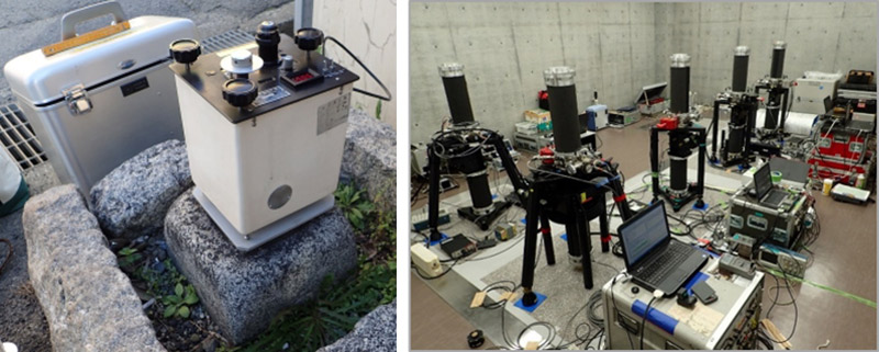 Left: The relative gravimeter used for measurement practice. Right: Instrument checking underway in the Gravity Measurement Room; the five black devices are FG5 absolute gravimeters. Photos provided by the GSI.
A box-shaped relative gravimeter, which measured 25 centimeters (9.8 inches) along its sides, was used by summer camp participants for measurement practice. This device contains a spring kept at a constant temperature via a heater, and a microscope is used to observe spring positions. It is placed in various locations to determine gravity levels, and supposedly boasts a precision down to the one one-millionth of a gal. I watched as participants practiced taking measurements based on the following process:
- Check relative gravity readings both on the marble floor surface and at an elevated location atop a rack
- Use a tape measure to measure the distance from the floor to the surface of the rack
- Calculate the per-meter gravity value difference based on said measurements
- Adjust based on a tidal correction chart to factor in the effects of gravitational pull from the Moon and Sun
- Repeat steps 1 through 4 multiple times and average out the resulting values
When expressing acceleration rates in fields such as geodesy and seismology, the unit "gal" is used—named after the famous Galileo Galilei. One Gal is equal to 1 cm/s2 (or 0.01 m/s2); gravity on Earth's surface is approximately 980 Gal. VGG calculations carried out by camp participants produced a result of 360 μGal/m, meaning a gravitational strength reduction of just 360/1,000,000 of a gal when elevated 1 meter above the floor.
Although such a slight variance has absolutely no effect on people's daily lives, I was still impressed to see that a gravitational difference did, in fact, exist, and could be clearly expressed as a number. Moreover, this number matched perfectly with past measurement results and calculations. I can still recall just how thrilled the students look upon seeing these results, as well as the equal level of relief on the GSI instructor's face at finding that the measurements had turned out as expected.
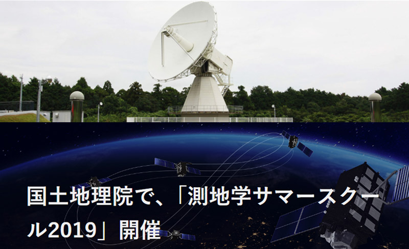 An article on the GSI's Geodesy Summer School 2019 is available in Japanese on the Michibiki (Quasi-Zenith Satellite System) website:
https://qzss.go.jp/info/archive/geod_190917.html
Observed VGGs are generally about 300 μGal/m throughout Japan, but the gradients at the Ishioka Geodetic Observing Station is approximately 360 μGal/m. The Ishioka Station is located in the identically named Ishioka (lit "stony mountain") region, where large concentrations of high-mass substances likely exist beneath the ground's surface.
I have talked about how simply taking a measurement atop a slightly elevated rack can result in changes to gravity values. It stands to reason, then, that measuring from an even higher elevation would result in greater variance. Field professionals conducted just such an experiment in 2020 in TOKYO SKYTREE, harnessing their knowledge and skills to take precision measurements. In part two of this article, I will provide an overview of that experiment and its goals, and also discuss how the experiment relates to GNSS.
Small But Significant Variances in Gravity and Time (Part Two of Two)
Writer introduction

Mr. Mitsunari Kita Science and technology writer
Born in Ishikawa Prefecture in 1964. Based on his experience in covering industrial technology, cutting-edge technology, and space development, he is passionate about unraveling and conveying difficult topics in an interesting way to people of all ages, from children to senior citizens. From 2009 to 2014, he was a member of the editorial board of "JAXA's," the official magazine of the Japan Aerospace Exploration Agency. Author and co-author of the following books: 『あなたにもミエル化? ~世間のなりたちを工学の視点から~』(幻冬舎mc)、『私たちの「はやぶさ」その時管制室で、彼らは何を思い、どう動いたか』(毎日新聞社)、『東京大学第二工学部70周年記念誌 工学の曙を支えた技術者達』(東京大学生産技術研究所) etc.,
* All registered trademarks used herein are the property of their respective owners.
Pick up


Column
FURUNO Column
Column by Mr. Mitsunari Kita (Science and technology writer)
-
FURUNO ELECTRIC Joins Experts From Around the World on a Norwegian Island for Jammertest 2024

-
Unraveling the Mysteries of Venus Based on "Occultation"
-
Atoms as the Basis for Measuring Both Fleeting Moments and Near-Eternities
-
Time Progressing with a Speed Difference of Just 4.4647 Ten-Billionths!
-
Critters Who Revitalize Forests Through the Spreading of Food Caches
-
Small But Significant Variances in Gravity and Time (Part Two of Two)
-
Small But Significant Variances in Gravity and Time (Part One of Two)
-
Why the GT-100 Time-synchronization GNSS Receiver Module is Like Fragrant Soup Curry
-
What Rainbows Can Teach Us About Dual-Band GNSS
-
The Amazing Things That Are Possible With Just a Clock
-
When Subterranean Earth Meets Outer Space
-
Using the TB-1 and GT-100 at a "Multipath Dojo" in the Major Metropolis of Osaka
-
The Disaster-struck Field Time Sync Generator TB-1: True Performance Revealed Through a Lightning Strike
-
Knowing the "Now" of Our Earth Through GNSS
-
The Reason GPS Counts Time in 1.5-second Intervals
-
Similarities Between "On My Count!," the 117 Notification System, and GPS
-
Reliable Clocks Help Us Find a Silver of the Clouds
-
Why Time Synchronization is Vital for Criminal Investigations, Seismograph Measurements and Solar Wind Observation
-
What Was "Cesium" About Cesium Akina?
-
Updating Analog Broadcasting with GNSS Time Synchronization Technology
-
The Long History of One Second (Part II)
-
The Long History of One Second (Part I)
-
A Solo Journey - Three-liter Microsatellite Mission Support via GPS (GNSS) and Satellite Communication -

-
A Solo Journey - The GPS (GNSS) Tracking System That Helped Kenichi Horie Cross the Pacific -
-
The Day After a Superflare - Effects on power and wireless communication infrastructures -